


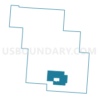
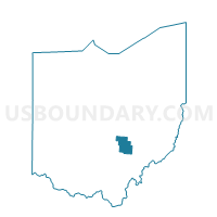
SALTLICK Voting District, Perry County, Ohio
About
Outline

Summary
| Unique Area Identifier | 650956 |
| Name | SALTLICK Voting District |
| County | Perry County |
| State | Ohio |
| Area (square miles) | 18.58 |
| Land Area (square miles) | 18.48 |
| Water Area (square miles) | 0.10 |
| % of Land Area | 99.44 |
| % of Water Area | 0.56 |
| Latitude of the Internal Point | 39.61964320 |
| Longtitude of the Internal Point | -82.19970090 |
Maps

Graphs
Select a template below for downloading or customizing gragh for SALTLICK Voting District, Perry County, Ohio


Neighbors
Neighoring Voting District (by Name) Neighboring Voting District on the Map
- COAL Voting District, Perry County, OH
- HEMLOCK Voting District, Perry County, OH
- JACKSON EAST Voting District, Perry County, OH
- MONDAY CREEK Voting District, Perry County, OH
- MONROE Voting District, Perry County, OH
- PIKE SOUTH Voting District, Perry County, OH
- PLEASANT Voting District, Perry County, OH
- SHAWNEE Voting District, Perry County, OH
Top 10 Neighboring County Subdivision (by Population) Neighboring County Subdivision on the Map
- Pike township, Perry County, OH (6,923)
- Jackson township, Perry County, OH (2,856)
- Monroe township, Perry County, OH (1,508)
- Salt Lick township, Perry County, OH (1,262)
- Coal township, Perry County, OH (1,042)
- Pleasant township, Perry County, OH (846)
- Monday Creek township, Perry County, OH (727)
Top 10 Neighboring Place (by Population) Neighboring Place on the Map
Top 10 Neighboring Unified School District (by Population) Neighboring Unified School District on the Map
- Logan-Hocking Local School District, OH (24,026)
- New Lexington City School District, OH (11,078)
- Southern Local School District, OH (4,814)